
To look at more info, you can see our .pdf itinerary here: https://drive.google.com/file/d/1x2E-InH93rHReLtjDBghpQ0pGNdSnzBH/view?usp=sharing
|
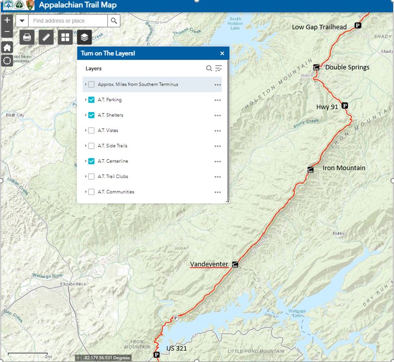
Low Gap Trailhead (Hwy421) to Laurel Branch Trailhead (Hwy321) = 27.1 miles |
|||||||||
|
LOCATION |
AT Mileage from Start |
Mileage Between |
Day |
Day Mileage |
High Temp |
Low Tepm |
Elevation (ft) |
Change |
Water |
|
US-421 – Low Gap, TN |
0 |
0.0 |
Wed AM |
60 |
44 |
3438 |
|||
|
Double Springs Shelter |
3.5 |
3.5 |
Wed PM |
3.5 |
48 |
40 |
4060 |
622 |
0.9 mile after DS Shelter |
|
TN91 |
6.5 |
3.0 |
3526 |
-534 |
0.8 after hwy 91 |
||||
|
Iron Mountain Shelter |
11.2 |
4.7 |
Thur PM |
7.7 |
50 |
41 |
4137 |
611 |
1.4 before shelter & 0.2 after |
|
Vandeventer Shelter |
18 |
6.8 |
Fri PM |
6.8 |
61 |
42 |
3491 |
-646 |
1.7 miles south |
|
US-321 – Hampton, TN |
27.1 |
9.1 |
Sat Exit |
9.1 |
61 |
34 |
2069 |
-1422 |
|
|
27.1 |
|||||||||
|
Watersource info here: |
http://www.wikitrail.org/features/view/at/25213/double-springs-shelter |
||||||||
|
From Home to Boots Off Hostel & Campground |
233 miles |
3 hrs 37 mins |
|||||||
|
From Boots Off Hostel to Low Gap Trailhead |
30.5 miles |
44 mins |
|||||||
|
Other Info: |
|||||||||
|
TN-91 to Lowgap Trailhead |
https://www.alltrails.com/trail/us/tennessee/appalachian-trail-tn-91-to-low-gap |